Grid: SD 996 055
I
conducted this short walk one evening at the end of what had been a lovely
spring day. Flat throughout its course and easy underfoot, the route is
suitable for people of all abilities and is wheelchair accessible too.
From
the car park adjacent to the Saddleworth Museum, I turned north along Uppermill’s
High Street, which is part of the former Oldham - Standedge turnpike road,
built in 1792. Turnpike Trusts were
established by Acts of Parliament between 1706 and the 1840’s to improve trade
routes throughout the country. The name ‘turnpike’ derives from the spiked
barriers that were erected across the road at some of the toll-houses.
 Although
many of the shops in the village had closed at the end of a busy day’s trading,
the pubs, café bars and restaurants were alive with customers enjoying a
pleasant evening socialising with friends. After passing through the square,
and beyond Kenworthy Gardens, I searched out an old milestone which is hidden
against a wall amongst some undergrowth. This historic marker has been damaged,
but still bears the inscriptions of Huddersfield and Ashton. In 1767, it was
made compulsory for mileposts to be positioned along the course of the turnpike
roads to inform travellers of direction and distance. In addition, they helped
the horse-drawn coaches to maintain their schedule and set fares. Prior to the
uniformed postal rate being introduced in 1840, postal charges were often
calculated using milepost markers.
Although
many of the shops in the village had closed at the end of a busy day’s trading,
the pubs, café bars and restaurants were alive with customers enjoying a
pleasant evening socialising with friends. After passing through the square,
and beyond Kenworthy Gardens, I searched out an old milestone which is hidden
against a wall amongst some undergrowth. This historic marker has been damaged,
but still bears the inscriptions of Huddersfield and Ashton. In 1767, it was
made compulsory for mileposts to be positioned along the course of the turnpike
roads to inform travellers of direction and distance. In addition, they helped
the horse-drawn coaches to maintain their schedule and set fares. Prior to the
uniformed postal rate being introduced in 1840, postal charges were often
calculated using milepost markers.
Continuing
on I passed the entrance to Saddleworth School, immediately beyond which, at
the foot of Ryefields Drive, stands a stone building with a bricked-up doorway.
In 1824 this house became the Brownhill Toll House from where the toll fees were
collected from traffic coming into Uppermill from the north.
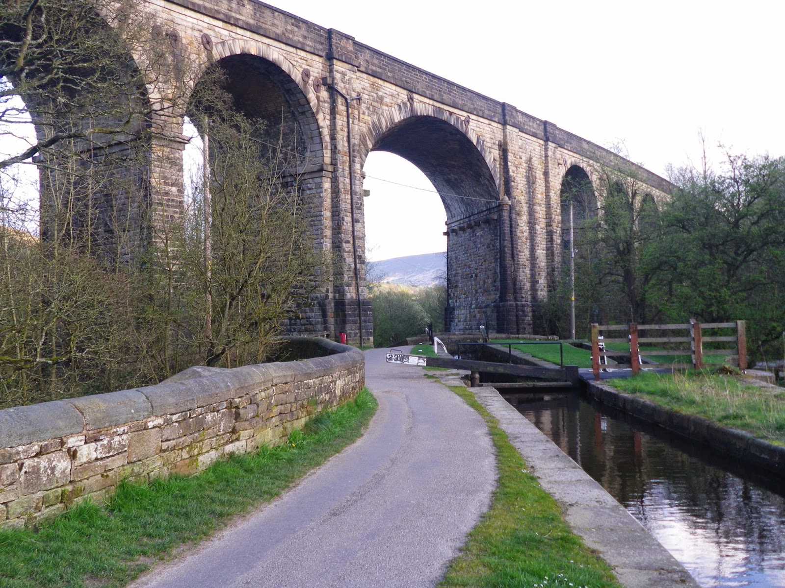
A
little further on, I passed underneath the massive, grade II listed, Uppermill
Viaduct. Its enormous stone arches span the width of the valley supporting the
railway, along which trains travel between Manchester and Huddersfield.
 Turning
left, I enter the car park of Brownhill Visitor Centre. This former transport
depot once housed a Countryside Visitor Centre which was staffed by countryside
rangers. Now it is the Lime Kiln Café where I opted to take a short break to
enjoy a cup of refreshing tea and one of their home-made cakes.
Turning
left, I enter the car park of Brownhill Visitor Centre. This former transport
depot once housed a Countryside Visitor Centre which was staffed by countryside
rangers. Now it is the Lime Kiln Café where I opted to take a short break to
enjoy a cup of refreshing tea and one of their home-made cakes.
Leaving
the café, I headed south along the towpath of the Huddersfield Narrow Canal. Built
in 1794, the 20 mile long canal has 74 locks and runs between Ashton and
Huddersfield. The summit of the canal is 645 feet above sea level, making it
the highest navigable waterway in Britain. To the north, the Standedge Canal
Tunnel cuts through the Pennines and is the longest, highest and deepest canal
tunnel in Britain.
At
Lime Kiln Lock, I passed underneath the unusual skewed arch of Saddleworth
Viaduct. Glancing down at the heavy wooden lock gates several fish broke the
surface of the still waters in search of an evening meal, whilst overhead a
couple of swallows, newly arrived from their wintering grounds, caught insects
on the wing.
From
here on, the towpath is sandwiched between the canal and the River Tame, and as
I continued the suns weakening rays struggled to break through the budding
canopy of overhanging trees. Opposite King George the V playing fields, a young
family crossed the stepping stones which, when the waters run low, provide dry
passage across the River Tame. On the rivers western bank, nestled amongst the
trees and foliage is a sculpture intended to form part of a series of art works
for a planned sculpture trail.
A
little further on is the picturesque Moorgate Bridge, where a beautifully
maintained narrow-boat was moored. At this point the towpath ends, and I crossed
the bridge to continue my walk along the opposite bank. Beyond here, are the
Wade Lock Moorings, I stood a while watching several broods of ducklings
frolicking in the still waters amongst the berthed canal boats.
 Passing
Wade Lock, I emerged onto Oldham Road. Turning right I walked away from
Uppermill for a short distance, past the site of another former toll house, to
take a look at the Brayshaw & Booth mile plate which stands outside No: 38.
Passing
Wade Lock, I emerged onto Oldham Road. Turning right I walked away from
Uppermill for a short distance, past the site of another former toll house, to
take a look at the Brayshaw & Booth mile plate which stands outside No: 38.
Retracing
my steps, I headed back towards the village, to the statue of Ammon Wrigley,
who was a local poet, writer and historian. Opposite here once stood the Wade
Lock Toll House.
Returning
to the car park, I reflected on what had been an enjoyable walk and that you
don’t always have to venture onto the high hills to see some wonderful sights
whilst in search of Saddleworth’s history.